
Customer success stories
and use cases
See how public sector leaders succeed with Urban SDK.
Urban SDK Raises $65M Growth Round from Riverwood Capital to Scale AI-Powered System of Action for Local Governments, Transforming Public Safety and Service
Funding Accelerates Expansion of Geospatial AI Technology, Helping Cities Efficiently Respond to Critical Safety Concerns
Urban SDK Raises $65M Growth Round from Riverwood Capital to Scale AI-Powered System of Action for Local Governments, Transforming Public Safety and Service
Funding Accelerates Expansion of Geospatial AI Technology, Helping Cities Efficiently Respond to Critical Safety Concerns

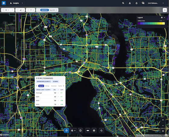
Traffic Volumes
Building Internal Traffic Analysis Capacity: A Roadmap for Reducing Consultant Reliance
Cities cut consultant reliance with mobility data to validate traffic calming, stop-control requests, and speed concerns using Urban SDK.
Traffic Volumes
Building Internal Traffic Analysis Capacity: A Roadmap for Reducing Consultant Reliance
Cities cut consultant reliance with mobility data to validate traffic calming, stop-control requests, and speed concerns using Urban SDK.
Traffic Volumes
How Cities Can Use Traffic Volume Variability to Evaluate Stop-Control Warrants
Cities use traffic volume and continuous data to assess stop-control warrants, prioritize requests, and make decisions with Urban SDK.
Traffic Volumes
How Cities Can Use Traffic Volume Variability to Evaluate Stop-Control Warrants
Cities use traffic volume and continuous data to assess stop-control warrants, prioritize requests, and make decisions with Urban SDK.

Transportation Planning
Understanding the 85th Percentile Rule: A Practical Guide Traffic Engineering
Learn how 85th percentile speeds guide traffic decisions and how continuous data helps cities validate requests, boost safety with Urban SDK
Transportation Planning
Understanding the 85th Percentile Rule: A Practical Guide Traffic Engineering
Learn how 85th percentile speeds guide traffic decisions and how continuous data helps cities validate requests, boost safety with Urban SDK

Road Safety
Speeding Perception vs. Reality: What Data Reveals About Neighborhood Traffic Concerns
Residents often misjudge speeding; continuous data helps cities verify concerns, spot true hotspots, and respond faster with Urban SDK.
Road Safety
Speeding Perception vs. Reality: What Data Reveals About Neighborhood Traffic Concerns
Residents often misjudge speeding; continuous data helps cities verify concerns, spot true hotspots, and respond faster with Urban SDK.

Traffic Calming
How Cities Can Replace Physical Speed Studies With Continuous Roadway Monitoring
Cities use continuous road monitoring to validate speeding complaints faster, cut costs, and improve traffic safety with Urban SDK.
Traffic Calming
How Cities Can Replace Physical Speed Studies With Continuous Roadway Monitoring
Cities use continuous road monitoring to validate speeding complaints faster, cut costs, and improve traffic safety with Urban SDK.

Traffic Calming
A Modern Framework for Handling Resident Speeding Complaints With Data Transparency
See how cities use real-time speed data to resolve speeding complaints faster, boost transparency, and build community trust with Urban SDK.
Traffic Calming
A Modern Framework for Handling Resident Speeding Complaints With Data Transparency
See how cities use real-time speed data to resolve speeding complaints faster, boost transparency, and build community trust with Urban SDK.

Transportation Planning
Winter Mobility Planning: How Traffic & Road Data Helps Cold-Climate Cities
See how traffic data help cities optimize snow plow routes, allocate resources efficiently, and keep roads safe during winter storms.
Transportation Planning
Winter Mobility Planning: How Traffic & Road Data Helps Cold-Climate Cities
See how traffic data help cities optimize snow plow routes, allocate resources efficiently, and keep roads safe during winter storms.
Congestion Management
Using Mobility Data to Keep Public Transit in Check and Make It Better
How mobility data helps transit agencies track on-time performance, optimize routes, improve reliability, and boost ridership.
Congestion Management
Using Mobility Data to Keep Public Transit in Check and Make It Better
How mobility data helps transit agencies track on-time performance, optimize routes, improve reliability, and boost ridership.
WEBINAR
Identify speeding and proactively enforce issues
See just how quick and easy it is to identify speeding, address complaints, and deploy officers.
