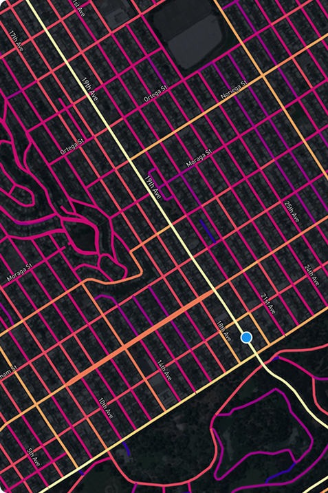
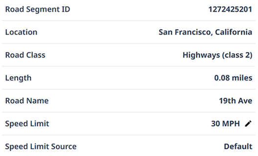
Click on any road below to analyze speed, volume, and safety with time-of-day trends — so you can prioritize the biggest issues first.
Trusted by 300+ Communities IN NORTH AMERICA


%203.png)


%203.png)
%203.png)
%202.png)
%203.png)
%202.png)

%203.png)


%202.png)


HOW IT WORKS
Respond to speeding complaints in 3 steps
Urban SDK identifies excessive speeding on all roadways with detailed traffic data, so you can focus on solving the problem.


Track your entire jurisdiction
Monitor traffic conditions across your entire county, city or by division.


Search for a specific address
Get traffic conditions for a specific address or nearby area.


Validate speeding complaints
Filter by speeds or get a report by selecting any road.
Identify speeding and resolve public complaints
Identify speeding and validate public complaints on any road in a matter of minutes.
61 MPH
85th Percentile Speed
Speed Limit
50 MPH
Average
54 MPH
95%
64 MPH

Road Segment ID
776737347
Location
San Francisco, California
Road Class
State Roads (class 3)
Length
0.08078 miles
Road Name
2A
Speed Limit
50 MPH
Speed Limit Source
Urban SDK
Data Layer
Traffic Speed
Gain access to traffic speed from connected vehicles on all your local roads. Insights reports allow users to gauge roadways with average, percentile speeds, and filter by time period or date ranges.
Urban SDK provides precise hourly speed data to evaluate complaints and deploy resources efficiently for the greatest impact to public safety.
Urban SDK provides precise hourly speed data to evaluate complaints and deploy resources efficiently for the greatest impact to public safety.

Daily Traffic
Traffic speeds are reported hourly on all roads without any hardware.

Road Network
Traffic speeds are associated with global linear referencing.

Customizable Analysis & Reporting
Filter traffic data to easily create custom reporting
- Speeds
- Speed Limit
- Road Class
- Segments
- Jurisdiction
- Time Period
- Date Range
- Day of Week
- Custom Route
- Custom Radius, Area, or Zone
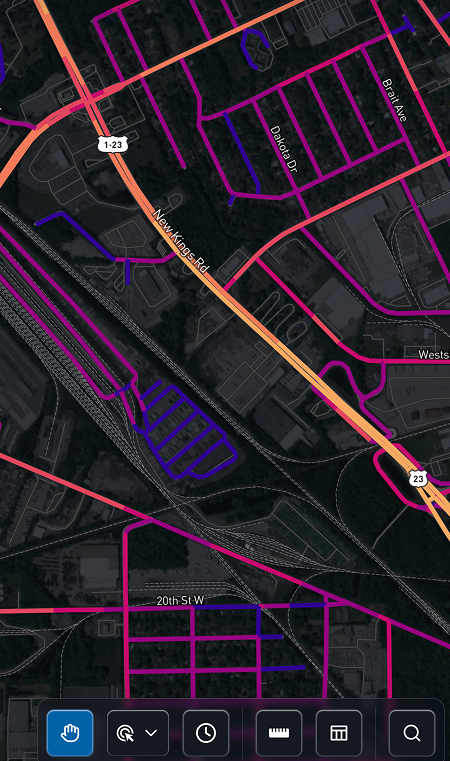
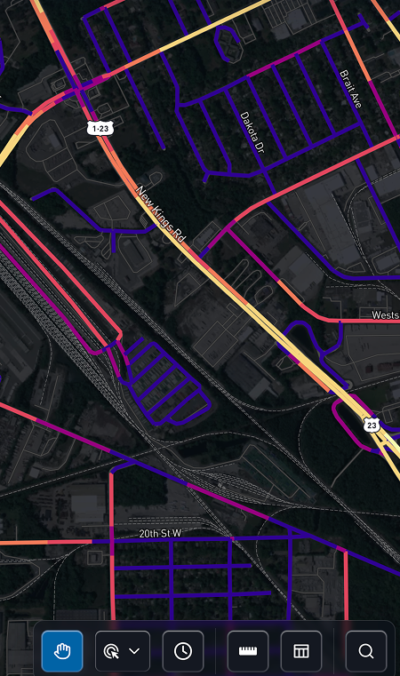
Quickly Identify Speeding to Position Enforcement
Visualize hotspots and compare speeds against posted speed limits.
12 MPH
Over Speed Limit
Speed Limit
45 MPH
85% Difference
12 MPH
95% Difference
17 MPH

Road Segment ID
120906391
Location
San Francisco, California
Road Class
Local (class 5)
Length
0.17523 miles
Road Name
New Kings Rd.
Speed Limit
45 MPH
Speed Limit Source
Urban SDK
Data Layer
Speed Limit Difference
Compare hourly speeds of observed trips on every road segment against the posted speed limit.
Urban SDK provides precise hourly speed data to evaluate complaints and deploy resources efficiently for the greatest impact to public safety.
Urban SDK provides precise hourly speed data to evaluate complaints and deploy resources efficiently for the greatest impact to public safety.
Average Difference
Compare average hourly traffic speeds.
85th & 95th
Compare 85th or 95th percentile hourly traffic speeds.
Import Speed Limits
Import your local speed limit files at any time or leverage Urban SDK's continuous speed limit index.
Mitigate collision risk with road scoring
Identify and rank roads with the highest collision risk from an annual road score.
.png)
0.82 Very High Risk
Collision Index
.png)
Data Layer
Collision Index
Using an index of 5-year historical fatal crashes, traffic volumes, speeding, roadway and neighborhood characteristics, officials can pinpoint hotspots across their entire roadway network.
Urban SDK provides precise hourly speed data to evaluate complaints and deploy resources efficiently for the greatest impact to public safety.
Urban SDK provides precise hourly speed data to evaluate complaints and deploy resources efficiently for the greatest impact to public safety.
Risk Score
The collision index creates a risk score value for each road segment ranging from 0 to 1
Dangerous Roads
Identify and monitor high collision corridors with bookmarks to alert traffic enforcement
Compare trends pre- and post- enforcement
Collision index models risk with collisions, traffic, and roadway design
- Intersection widths
- Sidewalks & facility widths
- School Zones
- Traffic Speed
- Collisions
- Signage
Get traffic volume on every road without hard counts
Daily and annual traffic volumes are available on every road. Counts are refreshed automatically.
2,400 Vehicles / Hour
AAHT
Road Segment ID
23614104
Location
San Francisco, California
Road Class
Local (class 5)
Length
0.06338 miles
Road Name
Pierce St
Speed Limit
30 MPH
Speed Limit Source
Urban SDK
Data Layer
Traffic Volume
Gain access to VMT and AADT on all your local roads with Urban SDK’s Traffic Volume Data. See how many cars are traveling along your roadways, and quickly share what roads are operating at capacity.
Urban SDK provides precise hourly speed data to evaluate complaints and deploy resources efficiently for the greatest impact to public safety.
Urban SDK provides precise hourly speed data to evaluate complaints and deploy resources efficiently for the greatest impact to public safety.
Annual Average Daily Traffic
Annual average daily traffic (AADT) measures how much traffic uses a road or highway in a year.
Vehicle Miles Traveled
Vehicle miles traveled (VMT) measures the amount of travel for all vehicles over a segment.
RETURN ON INVESTMENT
Join 300+ Communities in North America enabled by AI
Urban SDK provides precise hourly speed data to evaluate complaints and deploy resources efficiently for the greatest impact to public safety.
Urban SDK provides precise hourly speed data to evaluate complaints and deploy resources efficiently for the greatest impact to public safety.

Save Time
Replace manual tasks, outsourced analysis, and expensive hardware with data and AI.

Improve Safety
Identify lurking traffic safety, infrastructure conditions, and natural disaster risks.

Respond Faster
Respond to citizen complaints and clear your backlog sooner with fewer resources.

Report Progress
Generate custom reports, share data, and automate public complaints task work in just a few clicks.

Helping 300+ Communities
Validate Speeding Complaints
& Target Enforecement
See how geospatial AI is empowering proactive public safety in large and small communities.
ROAD SAFETY
Hendry County Uses Urban SDK to Enhance Traffic Safety
Hendry joins 50+ Florida organizations utilizing Urban SDK's platform

traffic calming
Athens-Clarke County Enhances Traffic Calming Initiatives
The county joins a growing number of Georgia customers using Urban SDK's platform
traffic calming
Collision Index: Proactive Traffic Safety Powered by AI
The county joins a growing number of Georgia customers using Urban SDK's platform

Road Safety
Battle Creek Partners with Urban SDK to Improve Road Safety
Officials will use Urban SDK to address speeding concerns in the community
ROAD SAFETY
Hendry County Uses Urban SDK to Enhance Traffic Safety
Hendry joins 50+ Florida organizations utilizing Urban SDK's platform
traffic calming
Athens-Clarke County Enhances Traffic Calming Initiatives
The county joins a growing number of Georgia customers using Urban SDK's platform
traffic calming
Collision Index: Proactive Traffic Safety Powered by AI
The county joins a growing number of Georgia customers using Urban SDK's platform

Road Safety
City of Verona Uses Urban SDK to Address Speeding on roadways
The partnership expands Urban SDK's presence in tri-state area.
ROAD SAFETY
Hendry County Uses Urban SDK to Enhance Traffic Safety
Hendry joins 50+ Florida organizations utilizing Urban SDK's platform
traffic calming
Athens-Clarke County Enhances Traffic Calming Initiatives
The county joins a growing number of Georgia customers using Urban SDK's platform
traffic calming
Collision Index: Proactive Traffic Safety Powered by AI
The county joins a growing number of Georgia customers using Urban SDK's platform

Road Safety
Urban SDK Welcomes Miami Gardens to Enhance Traffic Safety
Urban SDK Welcomes Miami Gardens, Florida to Enhance Traffic Safety
ROAD SAFETY
Hendry County Uses Urban SDK to Enhance Traffic Safety
Hendry joins 50+ Florida organizations utilizing Urban SDK's platform
traffic calming
Athens-Clarke County Enhances Traffic Calming Initiatives
The county joins a growing number of Georgia customers using Urban SDK's platform
traffic calming
Collision Index: Proactive Traffic Safety Powered by AI
The county joins a growing number of Georgia customers using Urban SDK's platform

Road Safety
Village of Pinecrest, Florida Partners with Urban SDK to Enhance Road Safety and Identify Traffic Hotspots
Pinecrest joins over 30 other Florida organizations to leverage Urban SDK for safer roadways.
ROAD SAFETY
Hendry County Uses Urban SDK to Enhance Traffic Safety
Hendry joins 50+ Florida organizations utilizing Urban SDK's platform
traffic calming
Athens-Clarke County Enhances Traffic Calming Initiatives
The county joins a growing number of Georgia customers using Urban SDK's platform
traffic calming
Collision Index: Proactive Traffic Safety Powered by AI
The county joins a growing number of Georgia customers using Urban SDK's platform

Traffic Calming
Urban SDK Partners with City of Ontario, California to Improve Road Safety and Traffic Calming Measures
Ontario to use Urban SDK to help with traffic calming and setting speed limits in the city.
ROAD SAFETY
Hendry County Uses Urban SDK to Enhance Traffic Safety
Hendry joins 50+ Florida organizations utilizing Urban SDK's platform
traffic calming
Athens-Clarke County Enhances Traffic Calming Initiatives
The county joins a growing number of Georgia customers using Urban SDK's platform
traffic calming
Collision Index: Proactive Traffic Safety Powered by AI
The county joins a growing number of Georgia customers using Urban SDK's platform

Road Safety
Urban SDK Partners with Farmers Branch to Enhance Traffic Safety
Farmers Branch and Urban SDK partner to address traffic safety measures in the North Texas community.
FREE TRIAL
Get Speeding Hotspots In Your Inbox
Urban SDK automates complaint response and targeted speeding enforecement for public safety.
