
Articles
Using Data to Assist First Responders
Big data and the Safe Streets initiative will help improve safety and operations for first responders around the country.
Big data and the Safe Streets initiative will help improve safety and operations for first responders around the country.
Even with improvements to street design and smart technology, crashes and incidents will always occur.
Drivers make errors. Defects happen in manufacturing. And even software can crash or be hacked.
As such, first responders will always be in demand for traffic issues, as well as anything demanding a public safety response — like fires, crimes in progress, medical emergencies etc.
The Safe Streets program is funding grants to help improve first responders’ work with technology. And while a safe street may force police cars to slow down on the way to the scene of a crash, they will hopefully be needed that much less often.
Database Integration
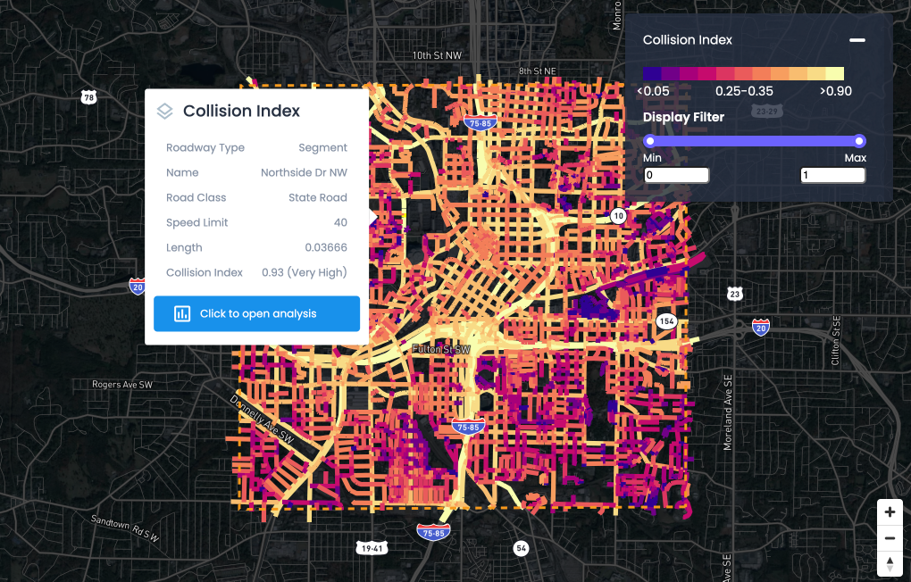
A key improvement to safety for which the program is funding grants to first responders is improving the way data on crashes is collected and reported.
Currently, according to the Governors Highway Safety Association, crash data is kept in local, state, and national databases. However, which database houses the data depends on which agency responds to the crash — and usually first responders and their databases don’t talk to each other.
On top of that, different agencies want different information, meaning data that is collected also varies from state to state.
According to a statement the GHSA released, crash investigators have limited resources to access technology in cars that can help them figure out what happened and the process of revising the forms is expensive and time-consuming.
Public-private partnerships can be an aid here. Urban SDK, for example, integrates with state and local safety databases to eliminate data silos. We also provide data normalization to ensure all parties have consistent crash data from which to report.
There is a lot of crash data out there, which can be very beneficial. The trick is ensuring it's useful (and accessible) for all parties that need it.
Keeping First Responders Safe
A growing concern for first responders is that sirens and flashing lights are increasingly insufficient in warning motorists, and collisions are growing in number. A Department of Homeland Security report even describes collisions with first responder vehicles as “growing at an alarming rate”.
As a result, agencies are looking into alternatives.
This is another area where safe, walkable streets will increase safety for first responders — since there will be less traffic, fewer collisions will occur. In July of 2021, a system called the Haas Alert was developed under contract to the DHS and uses responder-to-vehicle technology.
It uses the internet to alert drivers through smart phones and GPS. Other companies, including automakers, are building similar systems.
Some organizations are also utilizing machine learning to forecast crashes. This enables them to station responders near probable "hot spots" and mitigate crashes before they occur.
Dynamic GIS Mapping
Lastly, first responders need better ways to identify crash sites in order to get there faster.
People are not great judges of distance, and can often be in shock after a car crash, so on rural roads they may be only aware of where they are in vague terms ("past a dirt road", "by a large pasture", etc.) while in cities there could be multiple versions of an address (or they could be in a different municipality without realizing it).
In Boston, for example, because the city annexed several towns over the years, there are multiple Washington Streets, Adams Streets, Centre Streets, Bowdoin Streets, Cambridge Streets, and so on. So accurate geographical information is essential.
Washington, DC is divided into quarters so addresses also get a direction — NW, SE, SW, and NW — while other cities use one central street as an axis. But these systems still have limitations on account of being analog.
The internet of things could provide a solution: smart infrastructure in the street and sidewalk could provide accurate information to people’s phones and send it on to first responders, without having to find a mailbox or landmark.
Highways offer a similar conundrum: although many have mile markers between exits, they may not be visible in certain conditions or the crash could happen between two.
Increasingly, municipalities, counties and states are turning to GIS to help solve this and related public safety problems. These digital maps incorporate multiple layers of data — in addition to roads, train tracks, bodies of water, and other visible features.
A GIS map can also be dynamic, with first responders updating information from the field. This can dramatically decrease the uncertainty of figuring out where to send first responders and increase both response times and route optimization.
Combined with designing streets and transportation systems for safety, the Safe Streets and Roads For All program can help first responders adapt to today’s world and adopt the technology and techniques they need to best serve the public and deal with emergencies.
<hr></hr>
Learn more about how Urban SDK can help your organization make informed decisions using critical data. Contact our team here.

NEWS
Recent Announcements
See how public sector leaders succeed with Urban SDK.

Company News
Urban SDK Joins Government Technology’s AI Council to Help Shape the Future of AI in the Public Sector
We’re proud to announce that Urban SDK has officially joined the AI Council, part of Government Technology’s Center for Public Sector AI
Company News
Collision Index: Proactive Traffic Safety Powered by AI
Communities now have another layer of road safety thanks to Urban SDK’s Collision Index
Customer Stories
University of Florida Transportation Institute Partners with Urban SDK to Expand I-STREET Program
Urban SDK and the University of Florida have partnered to expand the university's I-STREET Program
WEBINAR
Identify speeding and proactively enforce issues
See just how quick and easy it is to identify speeding, address complaints, and deploy officers.
