

PARTNERSHIP oVerview
HERE x Urban SDK Referral
Urban SDK and Here have established a referral agreement to enable HERE employees to refer or resell data, software licenses and solutions internationally. Referrals provide initial commission and renewal commission for HERE employees.
Empowering the road forward.
Urban SDK are pioneers in geospatial AI technology — providing infrastructure leaders with innovative data and actionable insights for mission critical solutions anywhere in the nation. We are transforming the way decisions are made. And revolutionizing the way cities will be managed going forward. Urban SDK is a trusted leader in geospatial AI technology that are shaping what’s possible for 150+ local governments and business leaders across North America.
We equip critical public services with geospatial AI that empowers decisive action with precision and efficiency. Our vision is provide state, local government agencies and their consultants a future where every city is a model of precision, safety, and efficiency, driven by data and innovation.
Pain:
Municipalities leverage outdated, inefficient, expensive methods to collect data, turn it into accurate, usable information for decision making. State and local government agencies lack internal talent and bespoke data management tools to leverage big data analytics and AI to make public services more effective and cost efficient.
Solution:
Urban SDK provides software as a service and solution consulting to scale data collection and automated analysis of every road and critical asset through a robust data index of mobile advertising, video cameras, roadside sensors, drones, connected vehicle, and satellite imagery. Our proprietary analytics deliver key performance indicators with on every road and critical asset in the communities administrative boundaries. Our platform allows users to compare trends, respond to citizens immediately without a manual data collection, and better allocate their budget to taking action.
Our ROI:
Urban SDK provides a solution at $100/mi compared to the $Thousands city would spend per mile. This enables cities to use budgets more effectively, clear out a backlog of project requests with fewer staff and less outsourcing.
Company:
Urban SDK is based in Jacksonville, FL serving 150+ customers across North America with international expansion beginning in 2025. The company is backed by notable venture capital firms, profitable, and a long term HERE Technologies customer and partner.
Sales Process
Urban SDK and Here have established a referral agreement to enable HERE employees to refer or resell data, software licenses and solutions internationally. Referrals provide initial commission and renewal commission for HERE employees. For introduction, platform demonstration, pricing or sales related questions or to refer a lead please complete the form or contact sales@UrbanSDK.com. Our team operates on Monday through Friday Eastern Standard Time (EST) and will respond to referrals or inquires in no more than 2 business days.
New Leads
- Here Referral (Here Introduces Urban SDK)
- Here Traffic Analytics Renewal (Upsell AADT)
Referral
- HERE & Urban SDK conduct referral hand-off
Intro Call
- Urban SDK and prospect meet for introduction demo and pricing
Proposal
- Urban SDK provide prospect or HERE rep pricing proposal and contract license
- Urban SDK provides pipeline value summary to HERE to track deals
Contracting
- Urban SDK executes contracting, invoice and billing
- Urban SDK provides Close/Won value summary to HERE to track commissions
Onboarding, Renewal & Account Management
- Urban SDK assigns Account Manager for Onboarding and Training
- Urban SDK provides Customer with Service (e.g. AADT, Detection, R&D)
- Urban SDK manages renewal process
- Urban SDK provides Renewal Pipeline value summary to HERE to track renewal pipeline
- Urban SDK provides Renewal Close/Won value summary to HERE to track renewal commission
TARGET AUDIENCE
State, Local Government Agencies,
and Related Consultants
Urban SDK provides precise hourly speed data to evaluate complaints and deploy resources efficiently for the greatest impact to public safety.
Urban SDK provides precise hourly speed data to evaluate complaints and deploy resources efficiently for the greatest impact to public safety.

Public Works
City, County or Provincial departments responsible for transportation, infrastructure projects, public safety.

Law Enforcement
State, County, or City police departments responsible for public safety.

State DOTs
State departments responsible for transportation and infrastructure projects.

Emergency Management
State, County, or City departments responsible for management of natural disasters.
Overview of our
core offerings

INSIGHTS
Annual Traffic Volumes & Collision Risk
Urban SDK provides traffic counts, volumes, and collision risk to HERE Traffic Analytics customers and prospects.

OBJECT DETECTION
Geospatial object detection
Urban SDK provides AI, hardware, and software integration to detect vehicles, bikes, pedestrians, incidents and debris.

EMERGENCY MAnagement
Natural disaster mitigation & response
Urban SDK combines AI and real-time data collection for advanced disaster management and emergency response operations.

SYSTEMS INTEGRATION
Geospatial Analytics & App Development
Urban SDK offers geospatial software development and systems integration services. GIS Apps, BI, Computer Vision Modeling and integration.
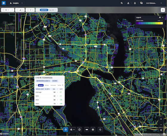
Mitigate collision risk with road scoring
Identify and rank roads with the highest collision risk from an annual road score.

0.57 (High)
Collision Index
Road Segment ID
1329450362
Location
San Francisco, California
Road Class
Local (class 5)
Length
0.11744 miles
Road Name
Perry St
Speed Limit
30 MPH
Data Layer
Collision Index
Using an index of 5-year historical fatal crashes, traffic volumes, speeding, roadway and neighborhood characteristics, officials can pinpoint hotspots across their entire roadway network.
Urban SDK provides precise hourly speed data to evaluate complaints and deploy resources efficiently for the greatest impact to public safety.
Urban SDK provides precise hourly speed data to evaluate complaints and deploy resources efficiently for the greatest impact to public safety.

Risk Score
The collision index creates a risk score value for each road segment ranging from 0 to 1

Dangerous Roads
Identify and monitor high collision corridors with bookmarks to alert traffic enforcement

Compare trends pre- and post- enforcement
Collision index models risk with collisions, traffic, and roadway design
- Intersection widths
- Sidewalks & facility widths
- School Zones
- Traffic Speed
- Collisions
- Signage
Get traffic volume on every road without hard counts
Daily and annual traffic volumes are available on every road. Counts are refreshed automatically.

1,500 vehicles
Volume (Annual Avg. Daily Traffic)
35,000 miles
Vehicle Miles Travelled (VMT)
Road Segment ID
23614104
Location
San Francisco, California
Road Class
Local (class 5)
Length
0.06338 miles
Road Name
Pierce St
Speed Limit
30 MPH
Speed Limit Source
Urban SDK
Data Layer
Traffic Volume
Gain access to VMT and AADT on all your local roads with Urban SDK’s Traffic Volume Data. See how many cars are traveling along your roadways, and quickly share what roads are operating at capacity.
Urban SDK provides precise hourly speed data to evaluate complaints and deploy resources efficiently for the greatest impact to public safety.
Urban SDK provides precise hourly speed data to evaluate complaints and deploy resources efficiently for the greatest impact to public safety.
Annual Average Daily Traffic
Annual average daily traffic appended to HERE Link ID.
Vehicle Miles Travelled
Annual vehicle miles travelled appended to HERE Link ID.
Natural disaster management for mitigation, response and resiliency
Improve emergency management with AI, real-time data, automated workflows, and reimbursement tracking.

Response Locations
986 Results

Streaming object detection from aerial assets
Urban SDK integrates live streaming and object detection AI to aerial assets for real time detection of emergency response locations such as flooding, property damage, debris, infrastructure and roadway damage.
Watch a Live StreamPlan & track mission routes
Urban SDK integrates vehicles, drones, and aerial assets for real time mission tour planning, priority scheduling and mission tracking for emergency response and restoration operations.
HALO
Emergency Management AI and Operations for Natural Disasters
Urban SDK is a proven emergency response management operator combining advanced mitigation, response and resilience technologies.
Urban SDK provides precise hourly speed data to evaluate complaints and deploy resources efficiently for the greatest impact to public safety.
Urban SDK provides precise hourly speed data to evaluate complaints and deploy resources efficiently for the greatest impact to public safety.
Disaster AI
Ai technologies proven in Hurricane ground zero for disaster mitigation and response.
Operations
Emergency operations logistics expertise and supplier network.
Asset Management & Integration
Proprietary response management software and technology integration across existing assets.
- Fleet Vehicles
- Helicopter
- Satellite SAR
- UAV
- Airplane
- BVLOS Drones
Visualize congestion on game day and special events
Improve game day and special event enforcement planning with historical hourly traffic analysis.

1.94
Travel Time Index
Speed Limit
30 MPH
85% Difference
2.01 MPH
95% Difference
2.01 MPH

Road Segment ID
120906391
Location
San Francisco, California
Road Class
Local (class 5)
Length
0.17523 miles
Road Name
Iowa St
Speed Limit
30 MPH
Speed Limit Source
Urban SDK
Data Layer
Special Events
See how special events and game day impacts congestion and routing in surrounding areas of major destinations with Travel Time, Travel Time Index and Planning Time on every road.
Urban SDK provides precise hourly speed data to evaluate complaints and deploy resources efficiently for the greatest impact to public safety.
Urban SDK provides precise hourly speed data to evaluate complaints and deploy resources efficiently for the greatest impact to public safety.
Travel Time
Three traffic delay layers quantify the impacts of congestion on travel time.
Historical Data
Access 13 months of historical hourly congestion to compare events.
Automate surveys with satellite image collection
Survey your entire roadway system instantly with GIS detail of physical and operational elements.

Road Segment ID
120906391
Location
San Francisco, California
Road Class
Local (class 5)
Length
0.17523 miles
Road Name
Iowa St
Speed Limit
30 MPH
Vehilce Lanes
2
Road Width
82 ft
Street Parking
None
Sidewalk Width
5 ft
Bike Lane Width
6.5 ft
Boulevard Width
18 ft
Type
Concrete
Bike Facility
Sharrow
Bike Separation
0
Road Length
521 ft
Data Layer
Road Characteristics
Road Characteristics are collected from aerial imagery and processed by Urban SDK to quantify road geometry and attributes that represent the road's 3D design.
Urban SDK provides precise hourly speed data to evaluate complaints and deploy resources efficiently for the greatest impact to public safety.
Urban SDK provides precise hourly speed data to evaluate complaints and deploy resources efficiently for the greatest impact to public safety.

Sidewalk & Bike Lane
Automate collection of sidewalk and bike lane inventories for all roads.

Parking
Automate on-street parking inventory on all roads.
Automate & Supplement Survey Collection
Import your local survey data and merge with additional
- Roadway Segmentation
- Speed Limit
- Road Classification
- Segment Length
- Road Width
- Vehicle Lanes
- Lane Width
- Sidewalk
- Sidewalk Width
- Bike Lane
- Bike Lane Width
- Separation Width
- On-Street Parking
- Road Surface Type
Customer success across
hundreds of cities
See how geospatial ai is empowering proactive public safety in large and small communities.
Urban SDK Raises $65M Growth Round from Riverwood Capital to Scale AI-Powered System of Action for Local Governments, Transforming Public Safety and Service
Funding Accelerates Expansion of Geospatial AI Technology, Helping Cities Efficiently Respond to Critical Safety Concerns
Traffic Volumes
Building Internal Traffic Analysis Capacity: A Roadmap for Reducing Consultant Reliance
Cities cut consultant reliance with mobility data to validate traffic calming, stop-control requests, and speed concerns using Urban SDK.
Traffic Volumes
How Cities Can Use Traffic Volume Variability to Evaluate Stop-Control Warrants
Cities use traffic volume and continuous data to assess stop-control warrants, prioritize requests, and make decisions with Urban SDK.