
Articles
Digital Twins used in Urban Planning and Infrastructure
As cities continue amassing massive amounts of data, digital twins will become increasingly valuable in urban planning and infrastructure projects.
As cities continue amassing massive amounts of data, digital twins will become increasingly valuable in urban planning and infrastructure projects.
The construction of digital twin models is growing in importance and interest in the urban planning world.
Cities generate and collect vast amounts of data. They have records going back years for many cases. And technological advances are making the collection and storage of even more kinds of data cheaper, and more accessible, than ever before.
Digital twins — which involve constructing digital models of a city’s terrain, buildings, and infrastructure, as well as simulating parameters like jobs, deliveries, traffic, and pollution — provide urban planners with both a deep look at their city’s inner workings and an idea of how a change might play out.
Digital Twins in Traffic Planning
One of the major ways digital twins are beginning to make a difference is with traffic planning.
Combining traffic simulations with the many layers of data represented by a digital twin can enable great insight.
City sources can help fill out how many off-street parking spaces are available, how much revenue they generate for the city, the amount of parking each building has, along with its expected trips.
This can help planners see how much traffic a new building might add to nearby streets and highways, as well as play around with potential ways to mitigate it.
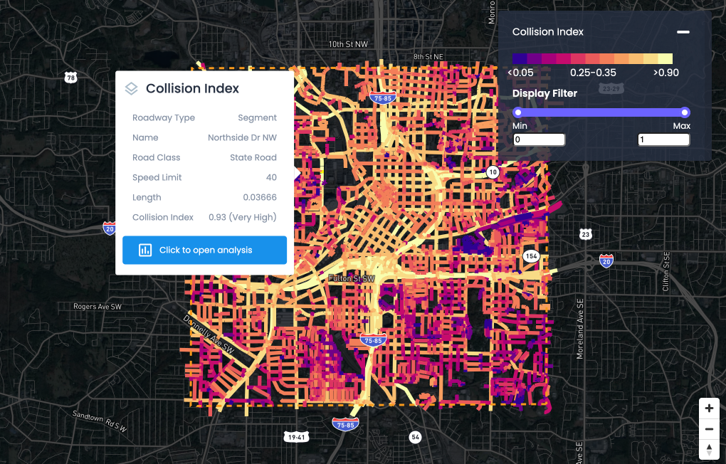
Crash data can also be added into the models, allowing planners to see dangerous stretches of road or intersections and experiment with different methods of improving safety, from re-timing traffic lights to traffic calming measures like road diets or roundabouts.
The models can also give planners an idea of how an intervention will affect a broader area.
Adjusting the lights may deal with crashes at one bad intersection, but it won’t be worth it if they end up causing problems elsewhere.
Energy Reduction
According to SmartCities Dive, digital twins are being used to reduce energy use, as well.
Property owners contribute their data and the twin can run simulations to find likely areas of improvement.
Tennessee’s Oak Ridge National Laboratory, which used public data to analyze 129 buildings across the country, built a tool called Automatic Building Energy Modeling. It can estimate both a building’s energy usage and what changes or retrofitting need to be done, with a goal of helping as many property owners get to net-zero as possible.
Using Digital Twins to Improve Processes
Another important use of digital twins in urban planning is streamlining the planning process itself.
The integrated nature of the models and sensors could allow planners to identify infrastructure in need to repair or replacement at every level — surface, water, sewer, gas, buried electric — and schedule work to be done together rather than piecemeal. This is important since such work can be very annoying to residents and taxpayers.
In Boston, planners are using digital models to investigate shadow impacts, while it’s also possible to use digital twins to check on zoning code compliance.
One day it may be possible to use the modeling technology for fire and building code inspections.
Disaster Mitigation
On a more practical level, some cities are using the sophisticated terrain mapping techniques to attempt to predict flood damage and perform other disaster mitigation.
This is harder than it sounds because not everything is mapped. Or it was mapped so long ago that conditions have changed.
It also depends on the kind of flood and environmental conditions.
For example, while cities like Boston and New York have obvious tunnel systems that could potentially be flooded, they also have less well-known underground spaces, like abandoned subway tunnels, underground parking garages, spaces built over air-rights, and small streams and creeks that were built over.
Boston also has extensive areas of landfill that respond flooding differently from both the natural geology and the pavement. Impervious services like asphalt are, however, one of the things that can make or greatly worsen a flood, since the water has to go somewhere.
As cities continue to collect more and more data and the scope and possibility of data collection grows, digital twins will become a must-have for any planning commission or agency, an indispensable tool for understanding the city’s workings.
FAQs
Q1: What are digital twins in urban planning?
Ans: A digital twin is a real-time digital model of a city's terrain, buildings, and infrastructure that simulates many parameters like traffic, pollution, and deliveries to help urban planners make informed decisions.
Q2: How do digital twins improve traffic planning?
Ans:Digital twins combine traffic simulations with layered city data to show impacts of new buildings on traffic and help design interventions like traffic calming, safer intersections, and better parking management.
Q3: Can digital twins help reduce energy usage in cities?
Ans: Yes, digital twins run simulations to identify energy use patterns and recommend retrofitting or improvements to help buildings and cities reduce energy consumption and move toward net-zero goals.
Q4: How do digital twins assist in urban infrastructure maintenance?
Ans: Integrated models allow planners to identify infrastructure in need of repair or replacement and schedule coordinated maintenance to minimize disruption to residents.
Q5: Are digital twins used for disaster mitigation?
Ans: Some cities use detailed terrain mapping in digital twins to predict flood damage and plan better for natural disasters, though modeling challenges remain due to underground and old infrastructure.
Q6: What data sources feed into digital twins?
Ans: Digital twins integrate GIS data, satellite imagery, sensor data, traffic feeds, and historical records to create a dynamic, constantly updated virtual city model.
Q7: How do digital twins affect urban planning decisions?
Ans: They allow planners to simulate “what-if” scenarios to evaluate potential impacts of construction, zoning changes, and climate adaptation strategies before implementation.
Q8: Can digital twins enhance public engagement in city planning?Ans: Yes, digital twins provide visualizations and interactive tools that let citizens explore proposed changes and provide feedback, fostering more transparent and inclusive planning.

NEWS
Recent Announcements
See how public sector leaders succeed with Urban SDK.

Company News
Urban SDK Joins Government Technology’s AI Council to Help Shape the Future of AI in the Public Sector
We’re proud to announce that Urban SDK has officially joined the AI Council, part of Government Technology’s Center for Public Sector AI
Company News
Collision Index: Proactive Traffic Safety Powered by AI
Communities now have another layer of road safety thanks to Urban SDK’s Collision Index
Customer Stories
University of Florida Transportation Institute Partners with Urban SDK to Expand I-STREET Program
Urban SDK and the University of Florida have partnered to expand the university's I-STREET Program
WEBINAR
Identify speeding and proactively enforce issues
See just how quick and easy it is to identify speeding, address complaints, and deploy officers.
