Get 30 days free
traffic data in any city
See just how quick and easy it is to identify speeding, address complaints, and deploy solutions.
Sign up to get access

Trusted by 300+ Communities IN NORTH AMERICA


%203.png)


%203.png)
%203.png)
%202.png)
%203.png)
%202.png)

%203.png)


%202.png)


WHAT"S INCLUDED IN THE TRIAL
Experience our platform in your city
Urban SDK indexes detailed traffic data, so you can focus on improving traffic, safety, and taking action.


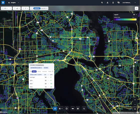
See your entire jurisdiction
Monitor traffic conditions across any county, city or jurisdiction.


Evaluate every road for 30 days
Get traffic conditions for a specific address or nearby area.


Validate traffic data
Get local reports of the last 30 days by selecting any road.
Watch Demo
Hourly traffic speed data and metrics from vehicle telematic and GPS data sources on all your roads.


Customer success across
hundreds of cities
See how geospatial ai is empowering large and small communities.
Urban SDK Raises $65M Growth Round from Riverwood Capital to Scale AI-Powered System of Action for Local Governments, Transforming Public Safety and Service
Funding Accelerates Expansion of Geospatial AI Technology, Helping Cities Efficiently Respond to Critical Safety Concerns
Urban SDK Raises $65M Growth Round from Riverwood Capital to Scale AI-Powered System of Action for Local Governments, Transforming Public Safety and Service
Funding Accelerates Expansion of Geospatial AI Technology, Helping Cities Efficiently Respond to Critical Safety Concerns
Traffic Volumes
Building Internal Traffic Analysis Capacity: A Roadmap for Reducing Consultant Reliance
Cities cut consultant reliance with mobility data to validate traffic calming, stop-control requests, and speed concerns using Urban SDK.
Traffic Volumes
Building Internal Traffic Analysis Capacity: A Roadmap for Reducing Consultant Reliance
Cities cut consultant reliance with mobility data to validate traffic calming, stop-control requests, and speed concerns using Urban SDK.
Traffic Volumes
How Cities Can Use Traffic Volume Variability to Evaluate Stop-Control Warrants
Cities use traffic volume and continuous data to assess stop-control warrants, prioritize requests, and make decisions with Urban SDK.
Traffic Volumes
How Cities Can Use Traffic Volume Variability to Evaluate Stop-Control Warrants
Cities use traffic volume and continuous data to assess stop-control warrants, prioritize requests, and make decisions with Urban SDK.

Transportation Planning
Understanding the 85th Percentile Rule: A Practical Guide Traffic Engineering
Learn how 85th percentile speeds guide traffic decisions and how continuous data helps cities validate requests, boost safety with Urban SDK
Transportation Planning
Understanding the 85th Percentile Rule: A Practical Guide Traffic Engineering
Learn how 85th percentile speeds guide traffic decisions and how continuous data helps cities validate requests, boost safety with Urban SDK

Road Safety
Speeding Perception vs. Reality: What Data Reveals About Neighborhood Traffic Concerns
Residents often misjudge speeding; continuous data helps cities verify concerns, spot true hotspots, and respond faster with Urban SDK.
Road Safety
Speeding Perception vs. Reality: What Data Reveals About Neighborhood Traffic Concerns
Residents often misjudge speeding; continuous data helps cities verify concerns, spot true hotspots, and respond faster with Urban SDK.

Traffic Calming
How Cities Can Replace Physical Speed Studies With Continuous Roadway Monitoring
Cities use continuous road monitoring to validate speeding complaints faster, cut costs, and improve traffic safety with Urban SDK.
Traffic Calming
How Cities Can Replace Physical Speed Studies With Continuous Roadway Monitoring
Cities use continuous road monitoring to validate speeding complaints faster, cut costs, and improve traffic safety with Urban SDK.